Email
davicom2011@gmail.com

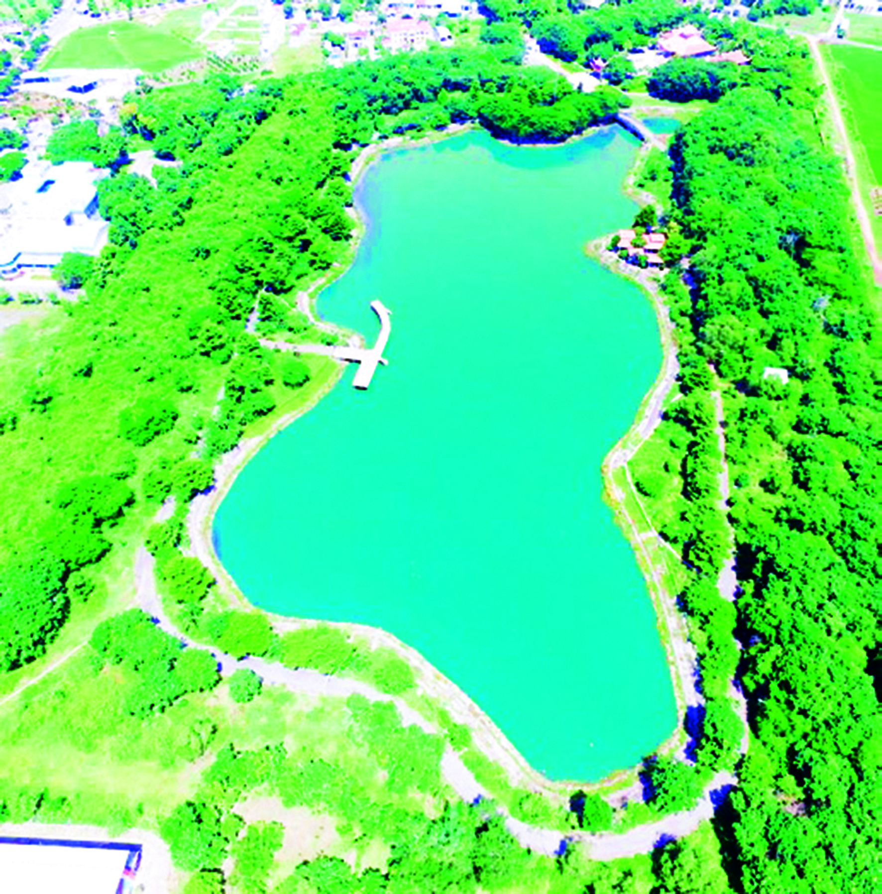
Following Highway 55, past the center of Long Dien town, near Long Dien communal house, to the East, you will see a water lake surrounded by a high land bank, with thick green bamboo clumps, like a city wall embracing the lake. That is Bau Thanh, because it is near the ancient citadel. This is a large rectangular lake (450 meters long, 250 meters wide), located about 100m to the East of Long Phuong communal house, Long Phuong hamlet, Long Dien town, at geographical coordinates 10029’318″ north latitude, 107013′ 400″ east longitude.
The total area of the Bau Thanh area is 24 hectares, and Bau Thanh has a circumference of 1,073 meters with a water surface area of 4.16 hectares, the deepest part is 4.6 meters. Bau Thanh is a rectangular, deep basin-shaped lake that stores fresh water from the annual rainy season. In the past, Bau Thanh contained fresh water all year round, never ran out, even when drought lasted for a long time. Therefore, folklore in the region also passed on the song:
“When Bung Bac stops being muddy
Bau Thanh runs out of water, then love is no longer.”
About 800 meters to the South of Bau Thanh is Go Cay Cam, a fairly large sand mound located in An Hoa hamlet, An Ngai commune. In 1999, while leveling the ground to open a road across the top of the mound, a stone statue was discovered. According to the assessment of the Archeology Center (Southern Institute of Social Sciences), this stone Buddha statue has the style of post-Oc Eo culture. This newly opened road runs across the top of the mound. The soil on the mound is dark gray sandy soil, and currently, the mound has been largely leveled to build houses. On the ground, there are some red ceramic pieces with hard, sandy bones belonging to the Chenla period (IX – X centuries). And based on the relics and archaeological documents at Bau Thanh, it shows that around the Bau Thanh relic area there are traces of the Funan people (I – VII centuries) and then the Chenla people, residents who lived here before the Vietnamese came to reclaim land and establish hamlets and open the country at the end of the 17th century. Therefore, Bau Thanh relic was formed around this time, from the 9th – 11th centuries, and the owners were indigenous people influenced by Indian culture who lived in the Long Dien area from the Funan period to modern times.
The ancients knew how to take advantage of natural terrain to dig water reservoirs, both saving time and manpower. On the other hand, when relying on natural mound terrain, they could meet the technical requirements of the water retention bank which is very solid.
Currently, Bau Thanh is surrounded by iron fences and stainless steel railings with a length of 1,037m surrounding the lake. Over many centuries, now the deepest part of the lake remains about 4 – 5m. The East and West banks have been flattened by later people for many different reasons; the Eastern bank is traditionally called giong cay Cay and the Southern bank is called giong Ba Thong. Now there is no longer bamboo and thorns like the old days, and green trees are planted for landscaping and for wood. The northern bank has a circumference of 821m, a height of over 11.7m, a surface of about 76m in width, and a length of 359m. The southern bank of Bau Thanh has a circumference of 876m, a length of 362m, a width of 45.5m, and a height of 13m. Bau Thanh historical relic belongs to Mo Xoai land, with a long history (nearly 400 years), associated with the history of Luy Phuoc Tu (Luy Mo Xoai, Luy Hung Phuc, Luy Huong Phuoc, Luy Bo Tam), the oldest relic of the Vietnamese people in the South. Bau Thanh was formerly known as “Duc Tuong Tri” (Elephant Bathing Pond) at the beginning of the border during the Nguyen Dynasty. Bau was near the garrison of the Cao Mien people, the General of Bon Tam Army used to bathe elephants, get water for elephants to drink.
This place marked the time when Cambodian soldiers were stationed under the command of General Bo Tam. Later, it was a military post of the Nguyen Dynasty to protect the peace and borders of the Mo Xoai land in the early days of exploring the Southern land of the Dai Viet people. It was here that two great battles of Dai Viet’s army and people were marked during the Nguyen Dynasty. The first battle in 1658 was led by Deputy General Dinh Tran Bien, Ton That Yen, and the second battle in 1674 was led by General Thai Khang Dinh, Nguyen Duong Lam, and Nguyen Dien was the pioneer to pacify Mo Xoai land. Both times defeated the Chenla army, destroyed the fortress, captured the citadel and the enemy generals, and then the Cambodian army did not dare to violate the border and harass the residents of Mo Xoai. In the two battles, it showed the determination of the army and people of Dai Viet under the Nguyen Dynasty to defeat the invading Chenla army at the top of the border (Mo Xoai), protect Vietnamese residents to reclaim the wasteland, form and build a community in the new land of the South. According to Trinh Hoai Duc: Mo Xoai Citadel (Phuoc Tu Citadel) associated with Bau Thanh is the oldest relic of the Vietnamese people in the South, at the time of reclamation and opening of the land of the South, Mo Xoai land where the Vietnamese first stopped in the South.
When the Nguyen Lords ruled the southern land, Mo Xoai belonged to Gia Dinh Phu, Tran Bien Dinh (a border town, a vital place) had a sea estuary and was covered with mountains and forests that were truly full of obstacles and difficulties. As the country’s border gate, the Nguyen Lords paid attention to the defense of this border region, established the governance system here according to the military regime, and placed military posts to protect the border lands.
Currently, Bau Thanh relic is a provincial-level historical and cultural relic, and protected in the Cultural and Sports Center of Long Dien district. This place recorded traces of the history of an ancient land that still remains open, needs research, and is a historical relic of a time at the frontier in the historical process of the Vietnamese people moving towards the South.


TƯ DUY – SÁNG TẠO
CÔNG NGHỆ - NĂNG ĐỘNG
© Davicom.com.vn. All Rights Reserved
 TƯ DUY – SÁNG TẠO